


Route Map
September 29th, 2014One of the really cool things about flying in one of Hawaiian Air’s Airbus 330s is the flight tracker that plays on the video screen. It provides all sorts of continuously updated data such as airspeed, air temperature, windspeed, altitude, time in the air, time to the destination, distance flown, distance remaining. It also shows the plane’s position on maps displayed at different scales, including one of the entire world, with night/day shown.
Here’s a really awful, shaky photo of one of the maps, taken just before we arrived on Maui:
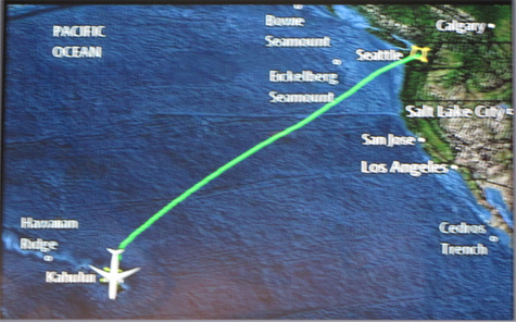
The only reason I’m inflicting this on you is because I am so intrigued that seamounts and oceanic trenches are included on the map!
If you squint you might be able to make out that, west of Seattle, two seamounts are labeled: the Bowie Seamount, which is apparently a navigation hazard to ocean-going traffic, and the Eickleberg Seamount, which Wikipedia refers to as the Cobb-Eickelberg Seamount chain. There is also the Cedros Trench off Baja California, and the Hawaiian Ridge.
Why are these features on the map?? Knowledge of their positions can’t be of any use to an aircraft — they’re all underwater. And why are these features on the map, and not other underwater features? I have no idea! I do like having them labeled though. It’s an acknowledgement that there’s more to the world than we usually notice. I just want to know why! 🙂
Posted on: Monday, September 29th, 2014 at 6:00 am
Categories: Meanderings.
September 29th, 2014 at 6:08 am
This sort of geological geekery on a map though, enthuses me. As useless as it is for an airplane map 🙂