Linda Nagata: the blog at Hahví.net


Rainier National Park: Lakes Trail

Friday, September 26th, 2014

A pond on Lakes Trail

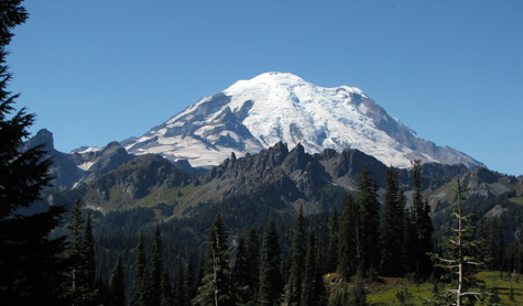
Ron and I visited Rainier National Park this past weekend. The last post talks about our hike to the lower glaciers along Skyline Trail on a blazingly hot Sunday. By contrast, on Monday morning we woke up to a light rain. This was a more familiar face of Rainier — but neither of us wanted to hike in the rain, so we wondered if we should stay. We were paying a lot for our hotel room and there is no TV, no Internet, no cell phone communication in the park. If the day turned out to be too wet to go hiking, I resolved that we would just check out a day early.

But by 10:30am the clouds broke up and the sky turned blue, so the hike was on!

This day was considerably cooler, but it was not cold. Late morning through early afternoon was sunny, but by late afternoon clouds had returned and I expected to get wet — but then the clouds broke up again. So once more, we were incredibly lucky with the weather.

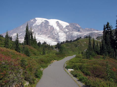
We weren’t quite as lucky with the trail. The Lakes Trail drops down below the visitor center to Reflection Lake, but there are two branches to the trail. The shorter one turned out to be closed because of ongoing repairs on a road that the trail crosses. So instead of hiking down, we started off hiking up above the visitor center on the same trail we’d taken the day before, to a junction with Lakes Trail, where we began our descent. This trail provided a very different experience from the day before, as we traversed meadows and passed through groves of evergreens. Along the way there were a couple of incredible view points, one of Steven’s Canyon, and the other from Faraway Rock.

Once we reached the bottom, we crossed the road and started up again, this time aiming to reach Pinnacle Peak, which we did in the early afternoon. We then turned around and hiked back down to the road, and then up again, to Paradise Inn. Total mileage for the day was 10.8 miles.
(more…)

Rainier National Park: Skyline Trail

Thursday, September 25th, 2014
Just inside the park entrance at Chinook Pass/ Cayuse Pass

Just inside the park entrance at Chinook Pass/ Cayuse Pass, September 20, 2014

Ron and I just got back from a ten-day trip to the state of Washington. We did a lot of sightseeing, including three nights at Paradise Inn — the only hotel in the park, located very close to the visitor center. This was the third time we’d been to Rainier. The first time, there was still a lot of snow on the ground, so we just drove around and had only occasional views of the mountain. The second time, the weather was rainy, there was ice in the parking lots, it was late fall so the visitor center was closed, and except for a brief glimpse, we didn’t see the mountain until we were driving away. But this time the weather was amazing!

The clearest day was the day we arrived. The sky was a stunning blue. But since we arrived late in the day, we didn’t do any hiking. The following day, Sunday, was incredibly hot — hot, at Mount Rainier! — I could hardly believe it. There wasn’t a cloud in the sky until very late in the day, but there was a brown haze, so it wasn’t quite as clear as the previous afternoon. I’m not complaining, though! We were incredibly fortunate.

I was concerned that the weather might turn wet by the next day so, prioritizing what we wanted to see — glaciers! — we set off from the Visitor Center, heading up Skyline Trail. We took the right branch of this loop trail so that we could venture directly to Paradise Glacier Trail. Skyline starts off paved on both branches, but gets a little rougher later on, especially after branching off to the glacier trail. Overall, though, trails were excellent all over, with just a few places suffering erosion. This being a gorgeous weekend, trails were also full of people out to enjoy the day.

We hiked a total of 8.7 miles, getting as high as the ridge alongside Pebble Creek. We didn’t try to hike up any further. If we had, we would have been crossing Nisqually Glacier below Camp Muir. The camp, I believe, is a staging area for those going to the summit.

The worst part of this hike, oddly enough, was the asphalt trail at the base, directly above the visitor center. This is the left branch of the loop trail, and was so incredibly steep that it was painful to descend after a full day of hiking.

Here’s the nicely paved start of the right-hand branch of Skyline Trail:
Beginning of Skyline Trail, the right hand branch of the loop
(more…)