Linda Nagata: the blog at Hahví.net


Archive for the 'Hiking' Category

Back From Arizona, Part 2

Saturday, March 17th, 2018

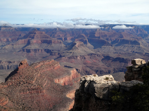
Ron and I spent the past week in Arizona. In my last post I talked about some of the sites on the way to the Grand Canyon. This post is about our canyon hike, down and then back up the Bright Angel Trail.

We arrived at the Grand Canyon late on Friday. After a traumatic but ultimately successful search for parking outside our hotel, we made it to our room. Very cold outside! We knew that rain was heading our way, but it wasn’t due to arrive until late Saturday. Regardless, we were going in.

The next day, Saturday, we set out from our hotel at 9:25am. The weather was cold with high clouds, but no rain yet.

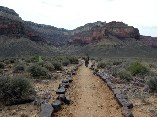
I’d hiked part of the Bright Angel trail once, long, long ago, in the summer. It had been so hot! This time, there was ice at the start of the trail. We went carefully and soon left most of the people behind, although there were always others on the trail, including some long-distance trail runners.

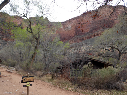
It wasn’t long before the temperature warmed up. We paused to take off some layers and then, stopping only briefly to snap a few photos, we made our way to Indian Gardens, 4.6 miles down the trail and a 3,000-foot drop in elevation. Yes, the downhill muscles were a bit tired of downhill at this point!

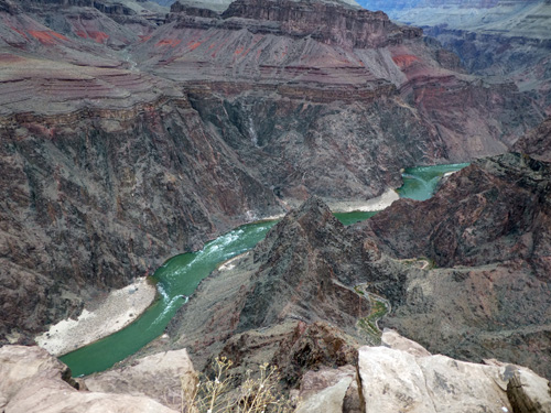
We had lunch and debated if we should add an extra three miles to our trek by heading out to Plateau Point. My courage was fading as I looked up at the cliffs we would have to climb to get out, but then I interrogated someone who’d just returned from the point and his enthusiastic recommendation decided us. We headed on.

Fortunately, this section was nearly level — and totally worth the effort. The view of the Colorado River was amazing! Absolutely the highlight of the hike.

Well, it was getting late. The day had been beautifully overcast, with curtains of rain over the north and east sections of the canyon. Great hiking weather. We hadn’t gotten wet yet, but it seemed inevitable. We set out, going at a steady pace, and sure enough the rain caught up with us, the drops hitting the light-colored trail dust, turning it dark. We got a little wet, but the rain was fairly light and kept us cool. Eventually I put on my rain jacket, mostly to avoid getting chilled.

Where there had been ice in the morning, there was thick gooey mud in the afternoon. That was kind of a bummer, but what can you do? We tromped on and managed not to fall down (thankfully we had our hiking sticks which helped immensely), and we reached the top a bit before 5pm. We’d done twelve miles on the trail and a bit more than that given that we walked to and from the hotel. So this was one of our longer day hikes — and a terrific one. The highlight of our trip.

I didn’t do any fiction writing while we were on the mainland. A whole week with no progress on the newest novel! But I wrote this post on the plane, so as you read this I’m already back to work.

Slacking

Thursday, May 12th, 2016

Back on April 21 I wrote a blog post about my intention to spend a lot less time and worry on social media, and focus instead on writing. Pretty radical agenda, huh? The tactic I used was to avoid Twitter, Facebook, SFWA forum, Book View Cafe forum, etc., as well as answering most emails, until after noon my time (6pm on the east coast). Mornings were devoted to writing. I get up pretty early, so this gave me a lot of time. I also managed some work most afternoons, and several evenings. In short, this strategy proved amazingly successful and I’ve made a lot of progress.

But I’ve begun to slip. I’m overly involved in Twitter again, in part because of the io9.com book club gig…and involvement with Twitter has led to squandering too much time online. Being immersed in a writing project does not mix well with promotional activities, at least for me! Which is fairly awkward when you’re trying to make a living as a writer.

Anyway, the writing really slowed down this week, and then yesterday I took the entire day off to hike in Haleakala Crater. The hike had the positive effect of getting me away from social media, though that wasn’t the reason we went. Ron is leading a volunteer group into the crater in a couple of days, and we were dropping supplies off at the cabin where they’ll be staying. So we enjoyed a twelve-mile roundtrip hike, with a 2600′ elevation change. The day was misty when we started. The mist was soon joined by a light rain that fell for most of the day, creating spectacular scenes on the crater floor. Here’s a shot Ron took of the ground steaming even as a light rain is falling. Click the image to see a stitched panorama:
(The panorama’s not great, but it’s the best I could manage…)
crater fog 2-500x209 - 2016.5.11 1316
When we climbed out of the crater, we were surprised to find the summit gloriously clear:
(click the image to see a larger version)

sea_of_clouds_500x281

Anyway, I’m resolved to get back to my write-until-noon schedule and get this book done. Onward!

Skyline Trail

Wednesday, November 4th, 2015

It’s launch day plus one for Going Dark.

Yesterday afternoon, instead of annoying my Twitter stream with “Hey, my book is out!” messages, I decided to go hiking on Haleakala’s Skyline Trail. This is an amazing route that starts at the summit and descends along the southwest rift zone into the forest at Polipoli State Park.

The complication with this hike is that you need someone to drop you off at the top and pick you up at the bottom. Luckily, my son had his day off, so we drafted him for that purpose. It turned into a fun afternoon, as well as a successful distraction from the stress of book launch.

Below: I call this “the road on the edge of the world.” This old road, which runs past the observatories and communications facilities at Haleakala’s summit, is the beginning of Skyline Trail:
Skyline Trail - road at the edge of the world
(more…)

Tiritiri Matangi Island

Monday, December 1st, 2014

Last New Zealand post!

Tiritiri Matangi Island is an amazingly successful ecological restoration project. The island itself is one of the Hauraki Gulf Islands off of Auckland. It used to be farmed, but beginning in 1984, rodents on the island were killed off and replanting was begun — the beginning of an immense volunteer project. Today the island’s vegetation is mostly native, and is home to many native bird species that thrive in the absence of introduced pest and predators.

Both Ron and I are interested in conservation, and we were told multiple times that we must visit the island — but we almost didn’t go. The weather during our last few days in Auckland was cold, windy, and wet, and a visit to an offshore island where we would need to remain for most of the day was not all that appealing. But we gathered our courage, and went anyway on our last full day in the city. And we were so glad we did!

The western side of the island, where we docked, was cold, a bit wet, and very windy as expected, but once we left the shore and entered the shelter of the bush, the weather wasn’t bad at all.

The island itself is beautiful, again with those amazingly well-kept New Zealand trails! The walks are guided by volunteers, which is wonderful for learning about the island’s history and having help sighting the native birds, which were very active during our visit. So yes! If you’re ever in Auckland, consider a visit. This is a wonderful conservation project, a great way to spend a day, and the hiking is easy.

Here’s our transportation, docked at Tiritiri Matangi Island.
TiriTiri1

 
The western shore, a photo that does not communicate the fierce wind that was blowing and an imminent, if passing, shower!
TiriTiri2

 
An oystercatcher nesting on the beach. This is my only semi-decent bird photo, and only because the subject was considerate enough to hold still!
TiriTiri3
(more…)

Taranaki Lookout

Thursday, November 20th, 2014

The walk to Taranaki Lookout was our second New Zealand hike. This one was much, much shorter than the Tongariro Alpine Crossing, but very different and fascinating. We did this one the day after Tongariro… well, actually, in the last half of the afternoon. It was only about 6.5 kilometers total, round trip.

This one was a rainforest hike. We walked from the hotel, through the little village of National Park, to a gravel road in a forest reserve. Just walking on the road was fascinating. The tree below is, I believe, a native cypress. Note the epiphytic ferns where the trunk begins to divide.
cypress_epiphytes

And this is what the road looks like… on our walk we saw only one other person on the road, a young woman on a bicycle who happened to work at our hotel.
the_road

We were following a map that was part of a brochure given to us by the hotel. Here’s the map. Note the distance through the town. Note the distance on the road and then the trail. As it turns out, this was not to scale. I admit I did not actually read the brochure…so before long as we were walking on the road I started to wonder aloud, “Did we miss the trail? We must have missed it. It’s not nearly this far on the map!” As it turns out, the brochure clearly states it’s two kilometers to the beginning of the trail, but the map makes the distance look much, much shorter!
map
(more…)

The Tongariro Alpine Crossing

Sunday, November 16th, 2014

Background: Ron and I arrived in Auckland on a cold spring day, when the sun was dueling with rain squalls that swept across the city at frequent intervals. I had a bad feeling about our upcoming hike. We were planning to do the Tongariro Alpine Crossing, a 12-mile day hike in Tongariro National Park. It’s one of the most popular day hikes in New Zealand, and described as “among the top ten single-day treks in the world.” But it wasn’t going to be a lot of fun if it involved constant rain, wind, or even snow. And in fact, snow fell the day before we arrived. But in an immense stroke of luck, the weather turned in our favor and we had an absolutely perfect day for hiking.

Logistics: we did not rent a car in New Zealand, for which, I believe, most Kiwis were grateful: American tourists unaccustomed to driving on the left side of the road evidently cause a lot of serious accidents. So we took a train — Kiwi Rail’s Northern Explorer — from Auckland to a little village called National Park, that’s just outside Tongariro National Park. We stayed at The Park Hotel at Ruapehu, which offered a hiking package. They picked us up at the train station and dropped us off at the trailhead early the next morning, along with a packed lunch. At the end of the day, they picked us up at the opposite end of the trail.

Geography: There are three active volcanoes in the center of Tongariro National Park. They are Ruapehu, Ngauruhoe, and Tongariro. The Crossing passes between Ngauruhoe and Tongariro over mostly volcanic terrain. The highest elevation is just over 6,000-feet. Here’s a map of the track.

Here’s Mount Ngauruhoe on the day we arrived. How’s that for a classic volcano profile? Summit elevation is 7,516 feet. I call this shot “The Road to Mount Doom” since Ngauruhoe served as Mount Doom in the LOTR movies.
road_to_mount_doom

And this is Mount Ruapehu on the same day, a much larger and taller mountain, standing at 9,177 feet.
Mt_Ruapehu_500px

(more…)

Rainier National Park: Lakes Trail

Friday, September 26th, 2014

A pond on Lakes Trail

Ron and I visited Rainier National Park this past weekend. The last post talks about our hike to the lower glaciers along Skyline Trail on a blazingly hot Sunday. By contrast, on Monday morning we woke up to a light rain. This was a more familiar face of Rainier — but neither of us wanted to hike in the rain, so we wondered if we should stay. We were paying a lot for our hotel room and there is no TV, no Internet, no cell phone communication in the park. If the day turned out to be too wet to go hiking, I resolved that we would just check out a day early.

But by 10:30am the clouds broke up and the sky turned blue, so the hike was on!

This day was considerably cooler, but it was not cold. Late morning through early afternoon was sunny, but by late afternoon clouds had returned and I expected to get wet — but then the clouds broke up again. So once more, we were incredibly lucky with the weather.

We weren’t quite as lucky with the trail. The Lakes Trail drops down below the visitor center to Reflection Lake, but there are two branches to the trail. The shorter one turned out to be closed because of ongoing repairs on a road that the trail crosses. So instead of hiking down, we started off hiking up above the visitor center on the same trail we’d taken the day before, to a junction with Lakes Trail, where we began our descent. This trail provided a very different experience from the day before, as we traversed meadows and passed through groves of evergreens. Along the way there were a couple of incredible view points, one of Steven’s Canyon, and the other from Faraway Rock.

Once we reached the bottom, we crossed the road and started up again, this time aiming to reach Pinnacle Peak, which we did in the early afternoon. We then turned around and hiked back down to the road, and then up again, to Paradise Inn. Total mileage for the day was 10.8 miles.
(more…)

Rainier National Park: Skyline Trail

Thursday, September 25th, 2014
Just inside the park entrance at Chinook Pass/ Cayuse Pass

Just inside the park entrance at Chinook Pass/ Cayuse Pass, September 20, 2014

Ron and I just got back from a ten-day trip to the state of Washington. We did a lot of sightseeing, including three nights at Paradise Inn — the only hotel in the park, located very close to the visitor center. This was the third time we’d been to Rainier. The first time, there was still a lot of snow on the ground, so we just drove around and had only occasional views of the mountain. The second time, the weather was rainy, there was ice in the parking lots, it was late fall so the visitor center was closed, and except for a brief glimpse, we didn’t see the mountain until we were driving away. But this time the weather was amazing!

The clearest day was the day we arrived. The sky was a stunning blue. But since we arrived late in the day, we didn’t do any hiking. The following day, Sunday, was incredibly hot — hot, at Mount Rainier! — I could hardly believe it. There wasn’t a cloud in the sky until very late in the day, but there was a brown haze, so it wasn’t quite as clear as the previous afternoon. I’m not complaining, though! We were incredibly fortunate.

I was concerned that the weather might turn wet by the next day so, prioritizing what we wanted to see — glaciers! — we set off from the Visitor Center, heading up Skyline Trail. We took the right branch of this loop trail so that we could venture directly to Paradise Glacier Trail. Skyline starts off paved on both branches, but gets a little rougher later on, especially after branching off to the glacier trail. Overall, though, trails were excellent all over, with just a few places suffering erosion. This being a gorgeous weekend, trails were also full of people out to enjoy the day.

We hiked a total of 8.7 miles, getting as high as the ridge alongside Pebble Creek. We didn’t try to hike up any further. If we had, we would have been crossing Nisqually Glacier below Camp Muir. The camp, I believe, is a staging area for those going to the summit.

The worst part of this hike, oddly enough, was the asphalt trail at the base, directly above the visitor center. This is the left branch of the loop trail, and was so incredibly steep that it was painful to descend after a full day of hiking.

Here’s the nicely paved start of the right-hand branch of Skyline Trail:
Beginning of Skyline Trail, the right hand branch of the loop
(more…)

Hilina Pali Trail

Saturday, August 2nd, 2014

Last week my husband Ron and I did some hiking on the Big Island. Our first venture was the Hilina Pali Trail, inside Hawaii Volcanoes National Park.

My quick summary?
Spectacular scenery, but not a pleasant hike. I’m glad we did it, but I doubt we’ll do it again.

Here I am at the start of the Hilina Pali Trail. It's all downhill from here -- that is, until it's time to head back.

Here I am at the start of the Hilina Pali Trail. It’s all downhill from here — that is, until it’s time to head back.
Photo by Ronald J. Nagata

(There are a lot more photos at the end of this write up!)

Here’s the longer version:

Volcanoes is a huge park, with extremely varied terrain that runs from the shoreline to Mauna Loa’s 14,000-foot summit. Hilina Pali — and “pali” is the Hawaiian word for “cliff” — is an escarpment on the southeast coast. The trail begins at the end of a nine-mile-long spur road that branches off from Chain-of-Craters Road. Starting elevation is about 2,260 feet. The trail descends a steep 1,200 feet through sometimes difficult terrain. It then crosses a wide bench, slowly descending another 800 feet. From here, it’s another 200-foot drop to near sea level. Roundtrip mileage is only around eight or nine miles according to the map, but I believe it’s significantly longer than this, by another mile or even two.

This is a tough hike! Not so much for the mileage, but because of the heat, the terrain, and the monotonous landscape. The initial descent is the hardest part of the hike. It can be quite steep, and the footing is treacherous in parts. It crosses an `a`a lava flow and some of the trail is paved in `a`a “clinker”–loose stones that can easily roll out from under your boot. I skidded several times on the way down and fell down once. The trail doesn’t seem to get a lot of use. Grass and weeds are overgrowing it, so it’s often hard to see where you’re placing your feet. And it’s hot. Did I mention it’s hot?

We were actually lucky, because a very strong wind was blowing all day. Now and then while on the cliff we would find ourselves in the lee, and it was sweltering!
(more…)

Rainforest Hike, Kauai

Monday, June 23rd, 2014

I enjoyed a very short trip to Kauai at the end of last week. One of the adventures I went on with my husband, Ron, was a short hike on the Pihea Trail in Koke’e State Park.

If you’ve visited Kauai, you’ve almost certainly been to Koke’e. I’ll bet the photo below looks familiar…this is a view into Kalalau Valley — it’s a standard stop for island visitors.

kalalau_valley

Nearly everyone who visits walks out along the eroded ridge that is the back wall of Kalalau Valley. That is the start of Pihea Trail, which continues along the ridge to a peak on the opposite side of the valley. It’s not very far — maybe 1.5 to two miles? — but there is some interesting terrain along the way. It’s good to remember, this is called a rainforest for a reason.
(more…)